|
Listen to this story
|
The Silicon Valley of India has been underwater for the past few days. Excessive rains coupled with poor infrastructure has left many parts of the cities submerged.
Urban floods are not uncommon in India. In the past few years, bigger cities like Chennai (2015) and Mumbai (2019) have faced the wrath of heavy downpours in a limited time period—eventually leading to floods. Interestingly, these are the cities where much of the modern smart infrastructure can be found.
The case of Bengaluru city is even more interesting as it is widely hailed as the technology capital of the country—with a keen integration of tech in several aspects of everyday city life. With the tech capital crumbling in the wake of incessant rains, the question naturally arises if there is a technological way out of this mess.
‘Digital Twins’ could be the answer
‘Digital Twins’, a concept put forth by David Gelernter in his 1991 book, ‘Mirror Worlds’, could be a potential solution for urban flood resilience.

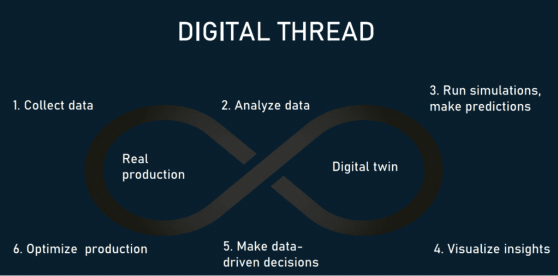
Digital Twins are digital or virtual copies of physical assets or products. They connect the real and the virtual world by collecting real-time data from installed sensors.
Digital Twins for Urban Flood Resilience: Examples from around the world
Many such flood-prone nations and their city authorities have resorted to ‘digital twins’ in order to ensure prompt and efficient response to such flood events—occurring due to torrential rains or other natural causes. This adoption of digital twins is also to ensure the mitigation of the havoc that they might wreak on the lives and livelihoods of those most affected by them.
In 2018, Newcastle University and Northumbrian Water came together with a plan to build a digital twin for the city of Newcastle to test hypothetical emergencies in the face of global climate change.
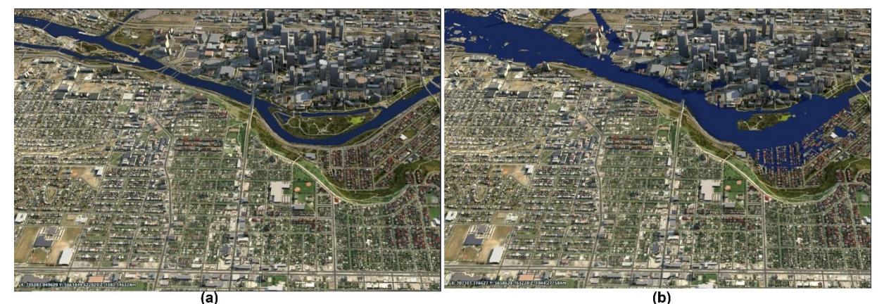
In 2021, a team of researchers from McMaster University, Canada, published a paper titled, ‘DIGITAL TWIN: A CITY-SCALE FLOOD IMITATION FRAMEWORK’, which laid down a framework for creating a city digital twin to simulate flood hazards. They created the digital twin for the city of Calgary through the integration of emerging technologies like sensors, Internet of Things, and satellites, infrastructure modelling, hydrology and hydraulic modelling, demographic information and interoperability translators and then calibrated with the historical flood of 2013. The idea was to simulate the effect of flood hazards and reduce the casualties and economic losses from such events.
Recently, the city government of Lisbon also decided to resort to digital twins for urban flood simulation so as to build the city’s flood resilience in the wake of extreme rainfall events and risks of rising sea levels. The objective was to use cutting-edge technology to build a drainage master plan for the city such that the working of the existing drainage infrastructure is optimised and proactive measures taken in the wake of emergencies.
The entire water cycle system from water distribution to storm water drainage management in the city of Porto, Portugal is supported by digital twin technology.
Digital Twins effective for urban flood resilience
Creating a digital twin for flood resilience in a city isn’t an easy task. It requires integration of several technologies like sensors, satellites, internet of things, city-scale infrastructure modelling, 3D mapping, hydrology and hydraulic modelling, interoperability translators along with demographic information and real time system behaviour.
Notwithstanding the cumbersomeness, it can fetch effective results. Flood resilience models created with the help of digital twins provide continuous imitations of hazards affecting the city infrastructures. They can identify vulnerable locations across the city and enhance the city’s resilience in the wake of climate-induced hazards.
Such virtual copies of physical assets could help develop reliable preparedness plans, mitigation strategies and test an infinite number of potential future emergencies. They can also tell the authorities which buildings are likely to be flooded and which infrastructure should be closed down in such an event. The technology could also determine human behaviour. For example, the most likely routes that people would use in the event of a flood.
In the case of Lisbon, the flood resilience model provided the authorities with a virtual representation of the impact of storm water flows in the city’s infrastructure and assets based on the velocity and direction of the flow of the storm water.
Banking on this information, the city authorities were able to build a fool-proof drainage master plan. It enabled them to identify the best trajectory and the size of the tunnels that were to be constructed. On the whole, it helped them to understand, evaluate and respond effectively to extreme weather events. Now, the city is able to efficiently analyse the water supply, wastewater and storm water to forecast flood risks and take preventive measures.