


|
Listen to this story
|
Bengaluru-based, Pixxel—India’s first company to launch private commercial satellites in space, is all set to launch Firefly—world’s first high-resolution hyperspectral satellites constellation (consists of six satellites) by 2024, specifically for geospatial study and analysis.
Over the past two years, Pixxel has deployed three highly functional satellites in orbit, each meticulously designed to decipher and convert vast data streams into actionable insights.
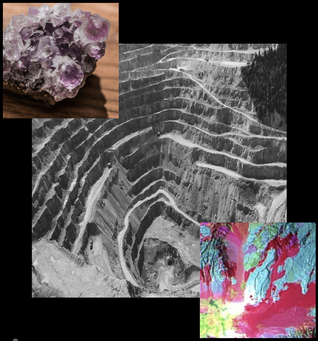
While conventional satellites captured data within a limited range, multispectral satellites added a few infrared bands, enabling observations beyond RGB. “Hyperspectral imagery enables us to capture information in hundreds of wavelengths, in our case about 300 units,” Awais Ahmed, Pixxel’s CEO and Founder, told AIM in an exclusive interview.
Simply put, Pixxel’s hyperspectral imaging system can discern a wide array of information from the electromagnetic spectrum captured by sensors. “Light is broken down into very minor, very thin sliced wavelength bands and depending on wavelength bands or data channels, you can decipher different information,” explained Ahmed.
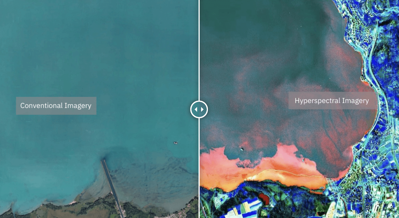
The use cases are plenty. In agriculture, Pixxel’s satellites identify crops and discern nutrient content in soils, gauge moisture levels, and assess chlorophyll content, enabling precision farming and crop management. These satellites detect methane leaks and differentiate between minerals for oil and gas sectors, offering unprecedented insights for mining companies. In forestry, they monitor pollution levels, track biodiversity changes, and identify pest infestations and tree species.

Pixxel’s hyperspectral satellite also helps in providing global coverage with the capability to revisit any location on Earth within a 24-hour cycle. “The goal is clear: We’re not just observing; we’re transforming the way industries operate, offering insights that empower decision-makers worldwide,” added Ahmed.
Solving One Pixxel at a Time
The journey to harnessing this vast amount of data hasn’t been without challenges. Managing the deluge of information, from capturing and storing it to processing it in real-time, has demanded technological upgrades. Pixxel’s edge computing capabilities, compression algorithms, and optimised storage systems have mitigated these hurdles, ensuring the reliability and accuracy of insights delivered.
Ahmed outlined three key issues in handling this immense data volume: capturing the vast amounts of data from the satellite, storing and downlinking, and caching it for quick access once available on the ground.
Pixxel has evolved its hardware over three years to resolve the data capture issue. Compression algorithms and on-board edge computing mitigate the challenge of downlinking vast data within limited satellite-ground station communication windows. This innovation significantly reduces the data needing transmission, optimising efficiency through increased downlink capacity or by processing data in space itself.
Moreover, on-ground storage strategies involve short- and long-term storage solutions tailored to varying data access needs. Pixxel’s approach involves innovative hardware solutions, compression algorithms, and a strategic mix of cloud-based storage to ensure efficient management and swift access to copious amounts of captured hyperspectral data.
“We are a vertically integrated company… from designing of the satellite to testing and building and operating is something that we do, including the edge computing parts of it,” explained Ahmed, highlighting the self-sufficiency in processing data for hyperspectral imagery.
Pixxel in Short
Founded in 2019 by Ahmed and co-founder CTO Kshitij Khandelwal, Pixxel has raised upwards of $70 million. The company, now comprising 175 employees globally, primarily centred in Bangalore, is extending operations to the US and Europe to cater to local needs.
The recent funding will also fuel the advancement of Aurora, Pixxel’s AI-driven analytics platform. This initiative seeks to democratise hyperspectral analysis, making it more accessible to a broader audience.
“We’ve been focusing on the Aurora platform, adding more features such as mathematical and statistical models, AI, and deep learning, supervised and unsupervised, to extract insights. For instance, land use and land cover classification can classify images in Asia into trees, water bodies, crops, and buildings, almost in real-time, without extensive training. There are other models like crop stress identification, biodiversity assessment, and oil and gas leak detection, among others,” said Ahmed.
Pixxel also boasts its partnerships with tech giants like Google, Microsoft, and Amazon. “The biggest thing that we depend on these companies for, first and foremost, is the cloud infrastructure.” This infrastructure and data marketplace access is crucial for storing and analysing vast amounts of data, enhancing data delivery and accessibility for users worldwide.
“Google Earth is used by 10s of 1000s of developers on the geospatial side to analyse satellite imagery,” said Ahmed. Meanwhile, Microsoft’s planetary computer and Amazon’s geospatial data marketplace cater to diverse user bases, enabling Pixxel to reach end-users efficiently.
What’s next?
With the Firefly series poised to embody the culmination of years of research and learning. These larger, more advanced satellites promise enhanced resolution, extended lifespans, and superior performance, setting the stage for a quantum leap in global-scale commercial operations.
With a global expansion strategy, Pixxel has set its sights on key markets, primarily in the United States and Europe. These regions, coupled with partnerships in Canada and Australia, form the crux of their customer base, with plans for further penetration into emerging markets in the years ahead.
Moreover, the $36 million in Series B funding will be used to deploy an additional 18 satellites by 2025, amplifying its capacity for data collection.